Image Recognition Solution
Image Recognition Solution
Client
Client
ArcSpan Systems
ArcSpan Systems
Industry
Industry
Power and Energy
Power and Energy
Client Needs
Client Needs
The client, an infrastructure inspection firm specializing in utility assets, needed a custom software solution to streamline how they monitor and assess power transmission towers. Their existing process relied heavily on manual inspection of image and point cloud data, which was time consuming, inconsistent, and difficult to scale as demand grew. They sought a centralized dashboard that could ingest high resolution RGB imagery, LiDAR point clouds, and location based data from drone flights and ground scans. The tool had to support real time visualization, enable defect identification (such as damaged insulators or corrosion), and provide tagging functionality for reporting and follow up action. Beyond visual clarity, the platform needed to integrate with existing scheduling and reporting workflows, support Slack notifications, and scale to manage hundreds of towers across different regions. Ultimately, the goal was to reduce inspection times, improve safety through automation, and provide engineers with a powerful interface to make faster, data backed decisions.
The client, an infrastructure inspection firm specializing in utility assets, needed a custom software solution to streamline how they monitor and assess power transmission towers. Their existing process relied heavily on manual inspection of image and point cloud data, which was time consuming, inconsistent, and difficult to scale as demand grew. They sought a centralized dashboard that could ingest high resolution RGB imagery, LiDAR point clouds, and location based data from drone flights and ground scans. The tool had to support real time visualization, enable defect identification (such as damaged insulators or corrosion), and provide tagging functionality for reporting and follow up action. Beyond visual clarity, the platform needed to integrate with existing scheduling and reporting workflows, support Slack notifications, and scale to manage hundreds of towers across different regions. Ultimately, the goal was to reduce inspection times, improve safety through automation, and provide engineers with a powerful interface to make faster, data backed decisions.
Our approach and solution
Our approach and solution
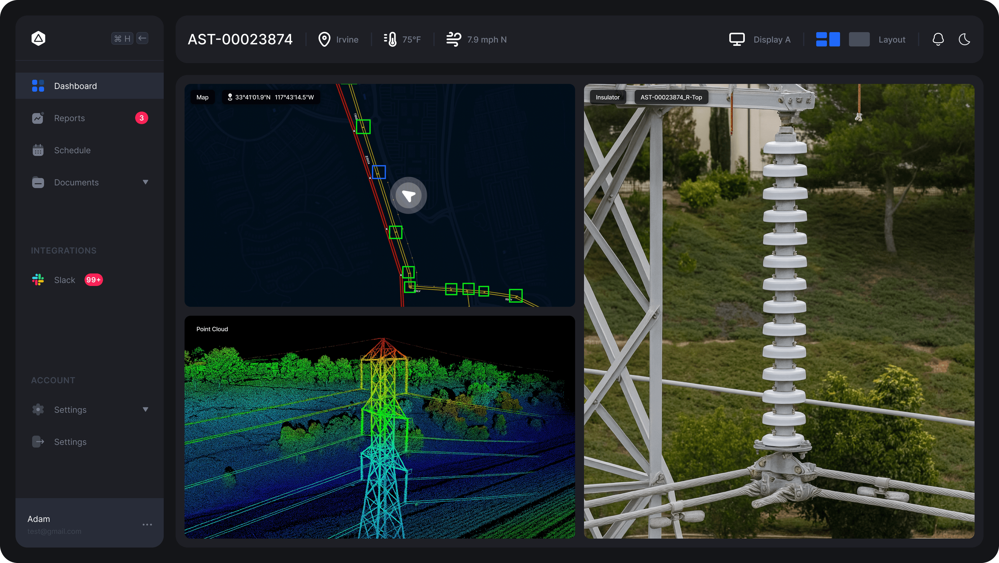
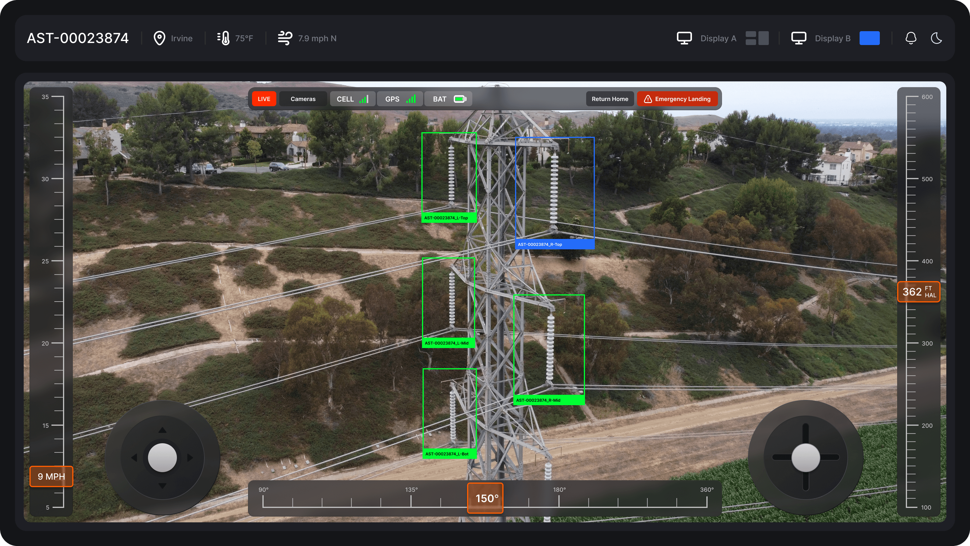
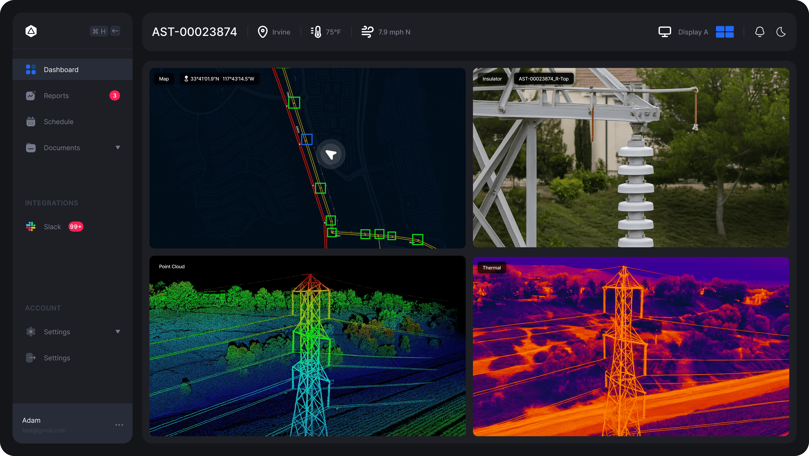
To meet the client’s need for scalable and automated tower inspection, we designed a fully integrated platform that combined drone imagery, LiDAR scans, and AI powered image recognition. Our approach focused on replacing manual review processes with intelligent automation while maintaining human oversight for quality control. The system begins with data ingestion, pulling in RGB images, LiDAR point clouds, and GPS data captured via autonomous drone missions. This data is then processed through an AI pipeline built on a combination of computer vision models trained to identify structural elements and detect defects such as missing bolts, corroded joints, or insulator cracks. To improve model accuracy, we annotated thousands of labeled tower components and failure cases. We used transfer learning with a Detectron2 backbone to speed up training and improve reliability on sparse datasets. The model runs inference on the server side, with results visualized in the dashboard as overlaid bounding boxes, semantic labels, and 3D map references. The user facing platform, built in React, offers an intuitive side by side view: high resolution images, thermal and point cloud data on one screen, and GIS integrated mapping on the other. Engineers can toggle layer visibility, validate AI findings, schedule inspections, and auto generate reports. The entire system integrates with Slack for alerts and AWS S3 for data storage. The solution drastically reduced inspection times and increased accuracy, while offering traceable, visual documentation that inspectors and field teams could rely on.
To meet the client’s need for scalable and automated tower inspection, we designed a fully integrated platform that combined drone imagery, LiDAR scans, and AI powered image recognition. Our approach focused on replacing manual review processes with intelligent automation while maintaining human oversight for quality control. The system begins with data ingestion, pulling in RGB images, LiDAR point clouds, and GPS data captured via autonomous drone missions. This data is then processed through an AI pipeline built on a combination of computer vision models trained to identify structural elements and detect defects such as missing bolts, corroded joints, or insulator cracks. To improve model accuracy, we annotated thousands of labeled tower components and failure cases. We used transfer learning with a Detectron2 backbone to speed up training and improve reliability on sparse datasets. The model runs inference on the server side, with results visualized in the dashboard as overlaid bounding boxes, semantic labels, and 3D map references. The user facing platform, built in React, offers an intuitive side by side view: high resolution images, thermal and point cloud data on one screen, and GIS integrated mapping on the other. Engineers can toggle layer visibility, validate AI findings, schedule inspections, and auto generate reports. The entire system integrates with Slack for alerts and AWS S3 for data storage. The solution drastically reduced inspection times and increased accuracy, while offering traceable, visual documentation that inspectors and field teams could rely on.

Tools & Technologies
Tools & Technologies
01
01
Frontend
Frontend
ReactJS with Tailwind CSS
Mapbox GL JS
Three.js (for 3D point cloud visualization)
ReactJS with Tailwind CSS
Mapbox GL JS
Three.js (for 3D point cloud visualization)
02
02
Backend
Backend
Node.js with Express.js
PostgreSQL + PostGIS (spatial queries and inspection history)
AWS S3 (image and model result storage)
Redis (caching model inference results for speed)
Node.js with Express.js
PostgreSQL + PostGIS (spatial queries and inspection history)
AWS S3 (image and model result storage)
Redis (caching model inference results for speed)
03
03
AI/ML Pipeline
AI/ML Pipeline
Detectron2 (for object detection and segmentation)
PyTorch (training and inference)
Label Studio (annotation and dataset management)
AWS SageMaker (training + batch inference)
OpenCV (image preprocessing and augmentation)
Detectron2 (for object detection and segmentation)
PyTorch (training and inference)
Label Studio (annotation and dataset management)
AWS SageMaker (training + batch inference)
OpenCV (image preprocessing and augmentation)
04
04
DevOps & Infrastructure
DevOps & Infrastructure
AWS EC2 (backend and inference services)
GitHub Actions (CI/CD)
NGINX (reverse proxy and load balancing)
Docker (containerization of ML services)
AWS EC2 (backend and inference services)
GitHub Actions (CI/CD)
NGINX (reverse proxy and load balancing)
Docker (containerization of ML services)
04
04
Integrations
Integrations
Slack (alerts and assignment updates)
Google Maps API (geocoding and satellite imagery support)
Slack (alerts and assignment updates)
Google Maps API (geocoding and satellite imagery support)
05
05
Testing & Monitoring
Testing & Monitoring
Jest (unit testing)
Prometheus + Grafana (performance and inference monitoring)
Sentry (error tracking)
Jest (unit testing)
Prometheus + Grafana (performance and inference monitoring)
Sentry (error tracking)